
Great Activities for Hikers
Upcoming Events + Activities
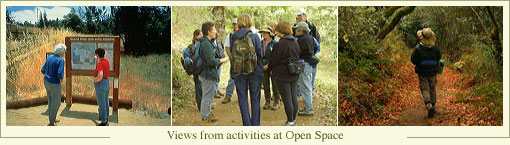
The District’s open space preserves are ideal for hiking. Whether you
are looking for a quick stroll to enjoy nature, an opportunity
to learn more about earthquakes, or an educational hike led by
one of our docents, hiking
allows you to enjoy your open space and marvel at the
natural beauty of this area.
Specific hikes of interest:
Nature Trail – The Stevens Creek Nature Trail passes through several
plant communities as it forms a three-mile loop at Monte Bello
Open Space Preserve. Interpretive signs guide the way as
you descend to the headwaters
of Stevens Creek and return along the San Andreas Fault. See below
for more details.
Fault Trail – Visitors can hike the easy 1.5-mile Fault Trail at
Los Trancos Open Space Preserve and learn how the mighty San Andreas
Fault has shaped our landscape. The brochure-guided hike is both informational and fun for all ages. is both informational and fun for all ages.
Docent-led Hikes – District docents lead over 200 outdooor activities
each year. Many of these focus on a particular theme or natural
history topic. Check out the Calendar of Activities to see what
docent-led activity interests
you!
Below is a list of other suggested hikes. Please see the Preserves page to find directions and review Trail Conditions before heading out.
Preserve: Monte Bello
Hike: Stevens Creek Nature Trail (3-mile loop). The Stevens Creek
Nature Trail, with self-guided interpretive stations along the way,
descends into the forested canyon, continues along the creek,
and heads back up through grasslands. The trail takes visitors through
many of the diverse ecosystems found on the Preserve. In the grassland,
one is
likely to see red-tailed hawks or turkey vultures soaring overhead,
or a coyote or bobcat hunting for rodents in the fields. Herds of
black-tailed deer are
often seen in the grassland in the fall during the mating season.
Mountain lions have been spotted occasionally on this Preserve. As
the trail descends
into the forest, the temperature drops, the air becomes moist, and
the scent of bay trees pervades the air. The forest and riparian
corridor running along
Stevens Creek provide a lush environment for many species, including many ferns, Douglas firs, and herbs.
Preserve: Rancho San Antonio
Hike:
Wildcat Loop Trail (3 miles). A popular route for hikers and joggers,
the trail follows a creek into a cool, fern-walled narrow canyon,
ascends through chaparral to open meadows on the middle ridge, and
loops back to Deer Hollow Farm.
Lupine, poppies, and patches of blue-eyed grass bloom in the meadows in
spring. Visitors can pause or picnic here and, on a clear day, enjoy
spectacular views of Mt. Tamalpais to the north and Mt. Hamilton to the
east.
Preserve: Rancho San Antonio
Hike:
Black Mountain Trail (4 miles). The trail climbs through chaparral,
grassland, and oak woodland to the top of Black Mountain. At the top of
2,800-foot Black Mountain, there are other views west into Stevens
Creek Canyon and open space lands along the Skyline ridge, as well as
views of Santa Clara Valley.
Preserve: Saratoga Gap
Hike: Saratoga Gap Trail (2 miles). Dedicated as part of the Bay
Area Ridge Trail,the nearly two-mile multi-use trail parallels Skyline Boulevard
(Highway 35), and connects with trails leading to Sanborn-Skyline County Park,
Castle Rock and Big Basin State Parks, Upper Stevens Creek County Park, and
Long Ridge, Skyline Ridge, and Monte Bello Open Space Preserves, and beyond.
The primary entrance to the Preserve is the trailhead located at the corner
of Highway 35 and Highway 9, a short drive from bayside or Coastside.
All
visitors will enjoy the wooded forest scattered with Douglas fir,
redwood, and California nutmeg, and the more predominant species of
oak, madrone, and bay. Visitors with a careful eye may also spot late
blooming wildflowers
lining this beautiful trail. Attractive lichen-covered boulders and
sandstone rock outcroppings can also be seen from the trail. Preserve: Sierra Azul
Hike: Woods Trail (6.2 miles) Beginning at the Jacques Ridge parking
area, the trail takes visitors over the top of 3,000-foot Mt. El
Sombroso, through deep ravines with shady, cool groves of madrone,
and into the Kennedy-Limekiln Area trail
network. The Woods Trail also provides a less strenuous out-and-back
experience since it is fairly level over the first three miles.
Preserve: Windy Hill
Hike: Hamms Gulch, Eagle, Razorback Ridge, and Lost trails (8-mile
loop). Travel through grassland ridges and forests of redwood, fir,
and oak to the valley floor and back again.
If you like to recommend a hike to feature on this page, please email us at info@openspace.org.
|


